
By: Hayley S. Murray
The Texas Supreme Court has agreed to review the Thirteenth Court of Appeals decision in Ellison v. Three Rivers Acquisition LLC, 2019 WL 613262 (Tex. App.—Corpus Christi, 2019).
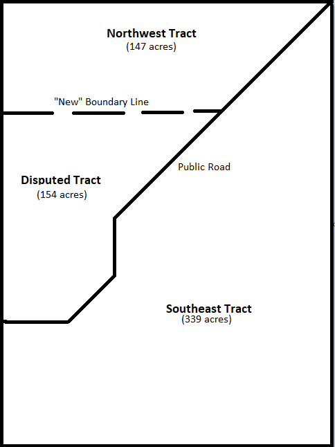
At the time of his death in 1925, J. D. Sugg was the owner of a 640-acre tract of land in Irion County, Texas (“Section 1”). On July 26, 1927, Sugg’s heirs executed a deed conveying several tracts of land to the Noelkes (the “1927 Deed”). The 1927 Deed described one of those tracts as
“All of Survey 1, Block 6, H & T.C. Ry. Co. lands located North and West of the public road which now runs across the corner of said Survey, containing 147 acres, more or less.”
By Patrician Deed dated 1930, the Sugg Estate purported to convey to A. A. Sugg the remaining 493 acres (the “Southeast Tract”). The Patrician Deed did not describe the boundaries or location of the remaining 493 acres. Instead it described the Southeast Tract as follows:
In 1939, the Sugg family commissioned a survey. According to the survey, the 1927 Deed conveyed that portion of Section 1 lying north and west of the public road (the “Northwest Tract”), which contained 301 acres instead of 147 acres as originally indicated in the 1927 Deed. According to the survey, the Northwest Tract includes the disputed 154 acres (the “Disputed Tract”).
In 1987, the mineral owners of the Northwest Tract granted four identical oil and gas leases covering the Northwest Tract. The description of the land leased in each of the leases was set forth as follows:
147 acre tract of land out of Survey 1, Block 6, H & TC Ry. Co. Survey, Abst. 312, lying N and W of the public road which runs NE and SW across said Survey 1, and being the same land conveyed to W.M. Hemphill, Trustee by E.S. Briant, Indep. Exec. of the Estate of J.D. Sugg, dec'd by Deed dated 7-26-27 & recorded in Bk. 17, Pg. 118.
Jamie Ellison, d/b/a Ellison Lease Operating (“Ellison”) ultimately acquired all of the leasehold interest in the leases. In 2006, the mineral owners of the Southeast Tract leased the Southeast Tract to Samson Oil (“Samson”).
In 2008, Samson sent a letter (the “Letter”) to Ellison describing a Boundary Stipulation purporting to resolve the discrepancy in the 1927 Deed by moving the boundary line between the Northwest Tract and the Southeast Tract to a new location in order to be consistent with the 1927 Deed’s purported conveyance of a total of 147 acres. As such, the question arose, did the 1927 Deed in fact convey the Northwest Tract, being all 301 acres northwest of the public road, or was it limited to the recited acreage amount of 147 acres despite the reference to “lands located North and West of the Public Road[?]” Below is a representation of the proposed new boundary line and the 154 acre tract in dispute (the “Disputed Tract”):
Ellison signed the Letter to Samson stating he agreed to the new boundary, but Samson never actually sent him the Boundary Stipulation. Further, neither the Letter nor the Boundary Stipulation contained words of conveyance. Samson subsequently drilled an oil well within the Disputed Tract.
In 2013, Ellison’s surviving spouse brought suit against various defendants pleading several causes of action, including a trespass-to-try-title claim against Samson and Concho (the Operator of the Southeast Tract). Concho moved for summary judgment, arguing the Letter relinquished ownership to the Disputed Tract and ratified the boundary as depicted in the Boundary Stipulation. The trial court granted Concho’s motion, holding that (i) the Boundary Stipulation established the boundary lines for the Northwest and Southeast Tracts and (ii) the Letter was enforceable on its terms. The Court of Appeals reversed and rendered a judgement in favor of Ellison.
The court first addressed whether the 1927 Deed was ambiguous in regard to the boundary line between the Northwest and Southeast Tracts. In reaching its conclusion, the court reasoned that inconsistencies between a metes-and-bounds description and recited acreage does not necessarily render an instrument as ambiguous. In such instances, the metes and bounds description controls. Because the 1927 Deed described the tract conveyed as being all of that portion of Section 1 lying north and west of the public road, and there was only one public road running through the section, the court concluded that the 1927 Deed unambiguously conveyed 301 acres—not 147 acres.
The court then addressed Concho’s argument that the Boundary Stipulation relinquished ownership to the Disputed Tract. The court held that the Boundary Stipulation was not a valid conveyance because (i) it did not identify a grantor or grantee, and (ii) did not contain operative words of grant showing an intention by a grantor to convey the Disputed Tract. Because the Boundary Stipulation sought to substantively change the boundary of the 1927 Deed, the court reasoned that the Boundary Stipulation was similar to a correction deed. As such, the Boundary Stipulation would be effective to move the boundary between the Northwest and Southeast Tracts only if it contained words of conveyance (like a deed) and complied with the Statute of Frauds. The court subsequently addressed Concho’s argument that the Letter ratified the boundary as depicted in the Boundary Stipulation. Because the court held the Boundary Stipulation was void and ineffective as a conveyance, the court reasoned that it could not be ratified. Further, because the Letter did not contain language of grant and failed to identify a grantor and grantee, the court concluded that the Letter itself could not be a valid conveyance.
Regardless of how the Texas Supreme Court rules on this case, Ellison v. Three Rivers Acquisition LLC is an important reminder that rules of construction will be utilized when construing portions of land descriptions that conflict or are ambiguous.